
Then, I dropped everything, opened a beer and dipped a chip in last night's camp-made guacaole, sat on the picnic table with a satisfied sigh, and toasted Mike Catterton, silently thanking him for teaching me the importance of prioritizing. I thought I would be well into Montana by now, but instead I'm in the same state in which I spent last night--Idaho--and a narrowish part of it, too, one that only takes a few hours to traverse by car. That's the beauty of a road trip, especially one that's done solo and with only a vague notion of an itinerary.
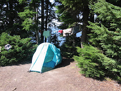
I committed to being in Cody, WY, by Friday evening and planned to do some sightseeing and hiking in Yellowstone along the way. It was past noon when I left home yesterday, hoping to get to the Lochsa, but by the time I hit the Idaho border, I was ready to call it a day. So, I pulled into Hellsgate State Park, practically in Lewiston, ID, and near the exit of Hell's Canyon on the Snake River. Urban camping at it's best, highway noise and jetboat traffic offered distraction from the RV villa all around me (the camp hosts have an RV with four slide-outs, two satellite dishes, a lawn sprinkler, and a portable outdoor closet). I managed to find the tent loop and camped next to two Canadian motorcyclists who were on their second day of a month-long journey to Mexico when one of them got rear-ended on the nearby Indian reservation, totalling his bike and injuring his knee, thereby ending their vacation.
I've been tracing the Columbia River and its sources since I left Portland. I hugged the banks of the Columbia for miles, then paralleled the Snake to Idaho. This morning, I followed the Clearwater then it's middle fork to the point where the Selway and Lochsa meet up. The winding river canyon just got more and more scenic.
Rounding a bend, I saw a guy in river clothes with his thumb out. I don't typically pick up hitchhikers, but he was standing next to an empty raft trailer, so I was pretty sure he just needed a ride back up to his put-in. Sure enough, he's retired and was spending the day catarafting the river while his son, who just got out of college for the summer, kayaked it. I picked his brain for hikes in the area. He said it's a nice hike up to Stanley Hot Springs and gave me simple directions to the trailhead, then warned that it might not be possible to ford Boulder Creek this time of year and I shouldn't try it alone. I figured I would set out on the hike and see how far I got. I found the trailhead easily enough, but since the trails had numbers and no names, and the hot springs weren't labeled on the trailhead map, I wasn't entirely sure how to get there. No worries; it was a nice day and I would enjoy myself, hot springs or no hot springs.
They guy also didn't mention how far it was to the springs. "A nice hike" could mean a lot of things, but I got the notion it could be done in an afternoon. The trail climbed steeply away from Boulder Creek, then traversed the ridgeline and continued climbing more gradually. After almost an hour and a half, I reached a junction. Stanley Hot Springs was still not mentioned, so I had no idea which way to go. I continued up the main trail another mile or so and got a glimpse of the creek. I was fairly certain I would not be crossing that foaming, frothing chaos today and decided to turn back. On a whim, I decided to explore the other trail for a short ways. It promptly dropped down to Boulder Creek at an improbbable ford. But a small trail led upstream to a large campsite and a down tree that crossed a side channel. Assuming I would be stranded on the island, unable to cross the main part of the creek, I nevertheless balanced across on the log. The main channel was bridged by a large logjam, then another down tree across the final section.

Although falling into the water would almost certainly end in immediate hypothermia followed by death, straddling the tree and shimmying my way over using my hands to lift and push forward didn't seem like much of a risk. I expected to see a hot springs oasis just across the creek. Alas, the trail proceeded to climb and twist through the forest away from the creek. I knew the creek crossing was the primary obstacle to the springs; I just didn't know how far from the crossing the springs were. I did know that hot springs are typically associated with a water source and that I was getting farther away from any visible or audible streamflow. I gave myself 10 minutes to mandatory turnaround.

Momentarily, I spied a large, open campsite and grew optimistic that it was near the springs. Just as I processed that thought, I caught a whif of sulfur. Aha! I found it! I hadn't seen a soul since I started my hike and spent an hour in heat-soaked bliss. It was all perfect--the way the hot water trickled out of the ground and flowed through mosss-covered rocks to fill pools created by manmade rock dams. I was six miles from the trailhead and had this spectacular hot spring in the middle of the forest all to myself!

If I miss Yellowstone on this trip, I'll be a bit disappointed, but sometimes you just have to go where you're led. Right now, I'm happy to be camped on the Lochsa, just steps from the trailhead, and looking forward to tomorrow. Maybe I'll make a beeline for the Park. Perhaps I'll find another unexpected trail to hike or ride.

No comments:
Post a Comment