Wednesday, May 1, 2019

Packrafting the Escalante


April and November are my favorite months to leave Alaska, to escape the in-between seasons that aren't ideally suited to anything. My April work schedule had an unexpected and unusual 10-day gap that stoked the imagination. Utah Canyon country had been on my mind for some time; while I've done a fair amount of mountain biking in Utah, some of the best terrain cannot be accessed by bike.

We initially researched hiking options, then expanded our criteria: what if we incorporated packrafts? The Escalante River rose to the top of the Google search and immediately caught our attention. I had friends who were hoping to boat the same canyon later in the month and it had been on their bucket list for years. Photos were stunning and trip reports made it sound challenging but well within our skill set.

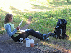
Unlike my friend Steve, who has been planning this trip for months and has a 2-inch thick folder of information and carefully marked maps, Jay and I read a few blog posts and trip reports and figured we could handle it.  The tricky part would be getting enough water in the river. Utah had a good snowpack this year, but the runoff had yet to materialize in the river. Unlike Steve and Holly, our dates were not flexible, so we had some alternative plans just in case. When we started out, the USGS gauge looked promising, with slowly increasing cfs and enough water to float a packraft.

On my one day off between work trips, I packed all my backpacking and packrafting gear in a pair of duffel bags. I scurried home from work at the end of my trip and in less than an hour, Jay and I were on our way back to the airport to catch a flight to Las Vegas. The next day, we stocked up on groceries, beer, and stove fuel, and made the 4.5-hour drive to Escalante, where we met up with Bobby and Grace who drove over from Telluride. We followed a friend's recommendation and had delicious pizza at Escalante Outfitters before making camp 16 miles out the washboarded Hole-in-the-Rock Road.

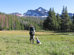
Next morning, we sorted gear and packed our backpacks. It took three hours to leave our rented truck at Forty-Mile Ridge Trailhead and drive back to Egypt Trailhead to start our journey. We ate a quick lunch of cold leftover pizza at the car, then began hiking downhill on the slickrock mesa in a chilly wind with spitting rain. This would be the only 10 minutes on the entire trip I needed my rain jacket.

Add caption


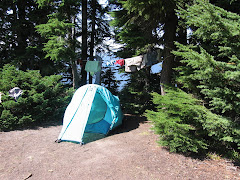
We followed cairns across the mesa and down a trail into Fence Canyon to the Escalante River, where we camped in a shaded grove next to a clear stream. We explored the bench across the creek and were rewarded with a petroglyph panel. It started to rain the moment we zipped our tents closed and rained most of the night.

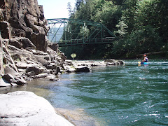
The sky was clear and blue the following morning. We put on the river about 10 a.m. and reached Golden Cathedral just in time for lunch. The river gauge read 3.5 before we hiked in, but the flow was slow and the river shallow. After a couple of bends, we encountered a river-wide tree that we had to climb over with our boats. It was an easy and pleasant hike up Neon Canyon under towering sandstone to a bowl with mossy walls, a deep pool, and a pair of holes overhead through which canyoneers rappel.

After a lazy lunch in the sun, we made our way back to our boats. Over the next four days, we bumped our way down the shallow river with frequent exits to drag boats over sand or gravel bars. We camped on a bench above Moody Creek, just below it's wide canyon. The almost-full moon rose above twin spires and bathed our tent in bright light until nearly sunrise.


The next day, Jay and I explored the lower part of Scorpion Gulch and acquired poison ivy rashes while Bobby and Grace napped on the quiet beach. We portaged the boats around Scorpion Rapid (the first of several "team-building opportunities") and struggled to stay in the deepest current where our boats would float rather than scrape over the abrasive sandstone rocks. We made camp on a sandy beach where the low-water rapid dictated another portage.


On Day 4 (Friday), we needed to put some river miles behind us so Bobby and Grace could get home on Saturday night. We weren't sure how long the hike out would take and we knew we had a 1.5-hour drive to their car, plus the 7-hour drive home for them. So we put on before 10 and stopped only for lunch. Averaging 2.5 miles per hour, we put in almost 17 miles that day. The scenery was stunning, but we were exhausted from the low water and repeated exits to scout and drag. Bobby snubbed his nose at several campsites before finally agreeing to a lovely beach in a goose-neck. We watched the now-full moon emerge above the canyon walls before drifting off to sleep.

I love river life and always hate to see the last day dawn. It was cool and cloudy for the first time since we launched, but the canyon walls still rose tall and red against the sky. In the final 10 miles, the river curved back on itself in countless goosenecks. When we saw Steven's Arch, we knew the takeout was near, but not before arcing around to see it from the other side. Then we hauled out on the beach at the mouth of Coyote Gulch, deflated the boats and packed our packs for the trek up to Forty-Mile.


The easy walk up Coyote ended all too soon as we reached the waterfall and the reknowned "sketchy" traverse out of the canyon and up to the sand dune. Bobby's youthful nimbleness came in handy here as Jay and I offloaded our packs to climb onto the ledge. Bobby shuttled packs as we inched our way across the steep, exposed slickrock shelf.

A couple college kids, Sam and Shelby, were hiking down the canyon and planned to hike out through the Crack in the Wall, as were we. However, they seemed unsure of the route and had suspect hiking fitness and experience. They were eager to follow us and soon became our new best friends.

Any relief at having survived the scary ledge traverse was quickly dampened by the sight of the sand dune that climbed relentlessly to the cliffs above. The first part was steep and hot, still sheltered from the breeze by the canyon. The only consolation was the view back toward the Escalante. Every step revealed a new layer of the canyon folding back on itself, and eventually a view of Steven's Arch from above.

We finally summited the dune and caught a brief rest in the shade until we realized the chore ahead of us: hauling our packs up the cliff as there was no way we could squeeze them through the Crack in the Wall. We had been warned that we would need a rope for this purpose and planned to use one of our river throw ropes, but found a 50-foot cordelette coiled at the base of the cliff. Bobby and Grace wiggled through the crack to pull packs from the top, while Jay and I stayed below to tie packs to the rope.

Sam and Shelby reached the wall just as we were about to tie the first pack to the rope that Bobby would haul up. They were completely unprepared for this aspect of the journey and were incredibly relieved and thankful to have us help them with their packs. Sam said he would give me anything I wanted once we were back at the cars. "Do you have cold beer?" I asked. "No," he said, "but we have hot water and a couple rotten bananas." Oh, well.


From the top of the crack, we could see the cars across the slickrock mesa. We followed cairns until we lost them. The wind blew so hard we could hardly stand upright and I thought my teeth needed a good scouring by sand anyway. We lost track of the cairns and made our way as far as we could on rock. We finally succumbed to the sand and found the trail leading up to the parking lot. When I crested the ridge, Bobby and Grace were collapsed in the shade of the truck, exhausted.


If you go:
The drive time to Escalante is about 4.5 hours from either Salt Lake City or Las Vegas, so pick your poison. The advantage of starting in Nevada is that you can stock up on road trip booze (you can buy real beer in Utah liquor stores, but there's not one in or near Escalante; you can only buy 4.0 beer in grocery and convenience stores in Utah).

Be sure to rent a vechicle with high clearance for the drive out Hole in the Rock Road and the rougher spur roads to the trailheads unless you hire a shuttle and leave your car in town. We reserved a standard SUV, but drove off the airport in a 4wd F150 which was a perfect rig for the job. Since we had two cars, we set our own shuttle, but there are several shuttle services in town as well as decent hitchhiking prospects.

The "grocery store" in Escalante is bare bones, so buy whatever food you need for the trip before you leave the metropolitan area. If you start in LAS, you will go through St. George on the way--Desert Rat is a nice local outdoor store where we bought fuel for the JetBoil, and just down the street is Angelica's a great spot for tacos and beer with outdoor seating.

There's plenty of free camping out Hole in the Rock Road. If you prefer more amenities, Escalante Outfitters rents cabins (and serves amazing pizza). The Prospector is an affordable and decent place to crash, and there are a couple RV parks at the west edge of town.

Dining options are limited, but good. Don't miss the pizza at Escalante Outfitters (we ate there before and after our river trip). Circle D Eatery has great food and service as well as free wifi. There are a couple other places in town that looked good, but we didn't get to try them all.

Escalante Outfitters and both RV parks have showers for about $7. The RV park on the south side of the road is closed on Sunday; the one on the north side has very nice showers with an ample supply of hot water.

Based on advice from previous paddlers and our time constraints (5 days including hike in/out), we started at Egypt and came out at Forty Mile. Starting just upstream at Harris Wash would give you the opportunity to hike up Silver Falls canyon. An easier but longer way out (and a shorter shuttle) is taking Coyote Wash to Hurricane Gulch. For a longer trip, you can put in at the bridge from Highway 12 and/or float all the way to Willow Creek.

We bought the Nat Geo Canyons of the Escalante map which provides a fair amount of detail, and USGS topos are available to download. A Google search will reveal a lot of information from prior trip in various conditions.

Have fun!!

Wednesday, May 16, 2018

Between Seasons on the Kenai

Presented with a few days off and weather and conditions not well suited to much of anything, Jay and I decided to put the camper on the truck, take our bikes, hiking gear, and packrafts, and see what trouble we could get into. We managed to leave by noon, stopped in Girdwood for a quick lunch for us and propane and water for the camper.

It was opening weekend for the Seaview Cafe, which just may be my favorite spot in Alaska. Live music was happening, so we made Hope our destination for the afternoon. Once there, we discovered one of the best things about off-season travel: free camping! The Porcupine Campground at the end of the Hope Road was gated open, but the fee station not yet installed. "No fees, no services," a sign announced. We were pleasantly surprised to find the outhouses unlocked and stocked with TP, but we had to supply our own water and trash disposal. No big deal.

We had the top popped in no time, changed into bike clothes, and immediately discovered that my bike had no pedals installed. I poached the pedals from my fatbike to put on my mountain bike last week in anticipation of summer, which apparently is canceled this year. So we switched to hiking clothes and headed up Hope Point trail to get some nice views of the Kenai mountains and Turnagain Arm, then walked to the Seaview for beers and music. We got a little drunk, danced a lot, and stumbled giggling back to camp where we passed out before dark (midnight?).


The best part of the week was having no agenda, sleeping as late as we wanted, sometimes starting a hike or ride late in the evening with no concern for darkness. The trees are finally budding, turning the landscape a bright, spring green. Wildlife is abundant, especially bird life--we must have seen hundreds of bald eagles. Finding a campsite was never a problem, although finding stores and restaurants open was (TripAdvisor update: there is no fish for sale in Homer!). We were so self-contained that it didn't matter. We explored nooks and crannies we had never been to before--Captain Cook State Park has great beach riding, there's free camping at a lovely beach at the mouth of the Kasilof River, and we watched bald eagles for half an hour at Deep Creek.


We camped across the road from the Time Bandit (Deadliest Catch, anyone?) on the Homer Spit and watched otters mating in the harbor. We drove back north and biked up the road to Tustamina Lake (the largest lake on the Kenai Peninsula), inflated our packrafts and floated the Kasilof River back to the truck. Along the way, we saw Arctic terns, bald eagles, mergansers, and a grizzly sow with two cubs. Angling toward home, we stopped in Cooper Landing to ride to Russian River Falls and continued up the trail until the wind and mud strongly encouraged a turn-back. On a whim, we walked down to the popular fishing area on the Russian River and promptly saw a black bear across the river. We watched him for ten minutes or so as he played, foraged for food, stood up and looked around (did he suspect we were there even though we were downwind?). We found more free camping at Portage, which also advertised supremely miserable weather (40 degrees and raining when we woke up).


We had a true Alaska moment when we were riding up the road to Tustamina Lake and encountered two moose who were less than enthusiastic about our presence. We hadn't seen a car since we left the highway six miles earlier, but a truck came up behind us, and the female passenger rolled her window down and asked if we'd like them to drive on the moose side while we rode on the safe side until we were past. Only the conversation was like this: "Would you like us to....?" "Yes, please!" then a wave and a nod once we were safely past the angry moose.

In a nutshell, off-season travel is the best: no crowds, no traffic, only a tiny bit of road construction, and a couple of mosquitos.

Tuesday, May 27, 2014

Solo Road Trip, Third Edition (2014)


I write this from the privacy of a walk-in campsite on the banks of Idaho's famous Lochsa River, savoring an excellent German Hefe and the long days of almost-summer. I pulled into camp with my usual efficiency, planning to get organized tout-suite

Then, I dropped everything, opened a beer and dipped a chip in last night's camp-made guacaole, sat on the picnic table with a satisfied sigh, and toasted Mike Catterton, silently thanking him for teaching me the importance of prioritizing. I thought I would be well into Montana by now, but instead I'm in the same state in which I spent last night--Idaho--and a narrowish part of it, too, one that only takes a few hours to traverse by car. That's the beauty of a road trip, especially one that's done solo and with only a vague notion of an itinerary. 

I committed to being in Cody, WY, by Friday evening and planned to do some sightseeing and hiking in Yellowstone along the way. It was past noon when I left home yesterday, hoping to get to the Lochsa, but by the time I hit the Idaho border, I was ready to call it a day. So, I pulled into Hellsgate State Park, practically in Lewiston, ID, and near the exit of Hell's Canyon on the Snake River. Urban camping at it's best, highway noise and jetboat traffic offered distraction from the RV villa all around me (the camp hosts have an RV with four slide-outs, two satellite dishes, a lawn sprinkler, and a portable outdoor closet). I managed to find the tent loop and camped next to two Canadian motorcyclists who were on their second day of a month-long journey to Mexico when one of them got rear-ended on the nearby Indian reservation, totalling his bike and injuring his knee, thereby ending their vacation. 

I've been tracing the Columbia River and its sources since I left Portland. I hugged the banks of the Columbia for miles, then paralleled the Snake to Idaho. This morning, I followed the Clearwater then it's middle fork to the point where the Selway and Lochsa meet up. The winding river canyon just got more and more scenic. 

Rounding a bend, I saw a guy in river clothes with his thumb out. I don't typically pick up hitchhikers, but he was standing next to an empty raft trailer, so I was pretty sure he just needed a ride back up to his put-in. Sure enough, he's retired and was spending the day catarafting the river while his son, who just got out of college for the summer, kayaked it. I picked his brain for hikes in the area. He said it's a nice hike up to Stanley Hot Springs and gave me simple directions to the trailhead, then warned that it might not be possible to ford Boulder Creek this time of year and I shouldn't try it alone. I figured I would set out on the hike and see how far I got. I found the trailhead easily enough, but since the trails had numbers and no names, and the hot springs weren't labeled on the trailhead map, I wasn't entirely sure how to get there. No worries; it was a nice day and I would enjoy myself, hot springs or no hot springs.

They guy also didn't mention how far it was to the springs. "A nice hike" could mean a lot of things, but I got the notion it could be done in an afternoon. The trail climbed steeply away from Boulder Creek, then traversed the ridgeline and continued climbing more gradually. After almost an hour and a half, I reached a junction. Stanley Hot Springs was still not mentioned, so I had no idea which way to go. I continued up the main trail another mile or so and got a glimpse of the creek. I was fairly certain I would not be crossing that foaming, frothing chaos today and decided to turn back. On a whim, I decided to explore the other trail for a short ways. It promptly dropped down to Boulder Creek at an improbbable ford. But a small trail led upstream to a large campsite and a down tree that crossed a side channel. Assuming I would be stranded on the island, unable to cross the main part of the creek, I nevertheless balanced across on the log. The main channel was bridged by a large logjam, then another down tree across the final section.


Although falling into the water would almost certainly end in immediate hypothermia followed by death, straddling the tree and shimmying my way over using my hands to lift and push forward didn't seem like much of a risk. I expected to see a hot springs oasis just across the creek. Alas, the trail proceeded to climb and twist through the forest away from the creek. I knew the creek crossing was the primary obstacle to the springs; I just didn't know how far from the crossing the springs were. I did know that hot springs are typically associated with a water source and that I was getting farther away from any visible or audible streamflow. I gave myself 10 minutes to mandatory turnaround.

Momentarily, I spied a large, open campsite and grew optimistic that it was near the springs. Just as I processed that thought, I caught a whif of sulfur. Aha! I found it! I hadn't seen a soul since I started my hike and spent an hour in heat-soaked bliss. It was all perfect--the way the hot water trickled out of the ground and flowed through mosss-covered rocks to fill pools created by manmade rock dams. I was six miles from the trailhead and had this spectacular hot spring in the  middle of the forest all to myself! 

If I miss Yellowstone on this trip, I'll be a bit disappointed, but sometimes you just have to go where you're led. Right now, I'm happy to be camped on the Lochsa, just steps from the trailhead, and looking forward to tomorrow. Maybe I'll make a beeline for the Park. Perhaps I'll find another unexpected trail to hike or ride.

Friday, February 7, 2014

The Year of the Sherman

One of my resolutions for 2014 was to write more and so far I haven't done a thing about it. I've thought about it formulated blog posts in my head, but always find 1,000 ways to procrastinate actually putting words to screen. Now I sit with a sinus infection watching the snow fall and I've exhaused all procrastination opportunities other than studying for my upcoming annual recurrent training. Writing seems like a great way to procrastinate studying!

I used to really enjoy writing my blog, then 2012 came along and sucked the life right out of me. The events of that year left me completely uninspired and withdrawn: a breakup combined with losing my dad and paternal grandmother all within a few months, plus some other life dramas.

I think it's healthy to allow a certain amount of time to wallow in self-pity, but then life must go on. I determined that 2013 must be a better year, and indeed it was! It had it's share of heartache for sure, but also more than a fair share of epic adventure, starting right off in January with a 12-hour solo mountain bike race in Arizona, followed by a whirlwind tour of Barcelona, Madrid, and New York; an epic week of riding Utah's Gooseberry Mesa trails with dear friends; a trip down the Yampa River in Colorado, where I unexpectedly met my boyfriend Jay; my first (and possibly last) mountain bike stage race, the Breck Epic, in August; and winding down in September after having the honor of competing on the US Mountain Bike Orienteering team at world champioinships in Estonia. 

You might notice I've changed the name of this blog from the highly uncreative "Susan's Adventures." My friend Vern announced on Facebook last summer that he was "going full Sherman" for the weekend. Someone asked what that meant and he replied, "Susan Sherman is a friend of mine who has more fun and adventure than anyone should be allowed." So "full Sherman" has become a common phrase among our circle of friends, along with jokes about "half Shermans" and "international Shermans." My upcoming move to Anchorage may invoke the "Arctic Sherman."

As active as I am, there are plenty of people who make me look like a couch potato: people who snow bike after work and ice climb and take advantage of every three-day-off-work opportunity to visit Iceland or Hawaii. I recently, from the comfort of my sofa in front of a fire with a glass of wine, watched a video about the Iditiasport Impossible (http://www.alaska.com/2008/10/16/2047/the-long-hard-race-iditasport.html). But my friend Ed recently offered to buy my couch if I ever wanted to sell it because he was confident in it's like-new state. 

Ed has also declared 2014 "The Year of the Sherman,"  although 2013 seemed like The Year of the Sherman to me. But that won't keep me from making the most of all that 2014 brings my way.


Wednesday, June 12, 2013

Bridget's Bodacious Bunchgrass Blowdown Boondoggle

As Randy climbed back into the shuttle van at 9:15 am, he was shaking his head and muttering something about the Donner Party. He had just dropped us off high on a dead-end mountain road and 27 miles of rugged ridgeline trail stood between us and the Brewers Union pub in Oakridge. We were pioneers on this early season recon of the Bunchgrass Ridge Trail, five hardy riders carrying a day's worth of food, water, and basic emergency equipment. We had shunned the long ride our friends were doing in favor of what was bound to be an epic summer day. 

Derrick led the way onto the inviting fir-lined singletrack as the morning sun shimmered through the trees. The remaining four of us eagerly fell in line.  About 40 yards in, we encoutered our first patch of snow. Undaunted, we rolled through it. Soon, the snow patches became more frequent and bigger--steep mounds that were impossible to ride up, so we got our shoes wet hiking up them. The trail starts around 6,000 feet and mostly descends from there, so we knew the snow wouldnt last long. But we weren't fooled by the net elevation loss. We had a series of burly climbs ahead.

Interspersed between snow piles were down trees and snags to climb over. Then we hiked up a steep meadow trail that was only defined by a series of markers and entered the Warner Creek Burn area. Hot and sweaty, we sat down on a log to eat sandwiches and swat mosquitos, noting that we had covered only 6.2 miles in nearly 2.5 hours. Not exactly record-breaking pace. Derrick had estimated our arrival at the pub for 3 p.m. We briefly discussed turning around, but no one took the notion very seriously. Derrick thought we might still make the 3:00 time if the trail opened up and became more rideable. This would be the first of many reassessments of our ETA.


About 10 yards later, we were handing our bikes over a large tree with a tangle of branches that snared spokes, shorts and skin. The trees kept coming and we were walking more than riding. The trail clung to a ridge between two bowls, then descended steeply into the one on the left before climbing steeply back out the other side. Derrick pointed out that this was the last best place to turn around--basically a point of no return--and all but insisted on abandoning our mission in light of the challenges that were keeping our progress to a snail's pace. But none of us were fond of the alternative--retracing our steps back to a forest road and riding it downhill to Highway 58 where we would commence the "pedal of shame" back to Oakridge. 


We all hemmed and hawed and said either way was fine, then Bridget finally spoke out. "I really want to keep going," she announced. Relieved, I chimed in, "me, too." "So do I," said Charlie. Suzanne did not object. Derrick shrugged his shoulders and said, "well at least you can't blame me," then lifted his bike over the 57th down tree. A few minutes later, I was able to coast at least 20 yards downhill before another forced dismount and I yelled "wheee!" with joy. Bridget, who was just in front of me, laughed. It had to be hilarious, otherwise it was a total suckfest.

The steep climb out of the bowl, still mostly hiking and hefting, was rewarded with 360-degree views of Mt. Jefferson, Three Sisters, Fuji, and Diamond Peak. Indian paintbrush and shooting stars were in bright bloom. Derrick nearly became the first Donner Party casualty when he boldly hefted a bottle of Coke out of his pack. We were on him like flies to horse dung. He offered to trade sips of Coke for food and we fell all over ourselves to be the lucky recipient. Derrick wisely opted for Suzanne's sandwich and Charlie whined, " but I want some Coke," when his proffered snack was not chosen. In the end, we all had sips of Coke, thus saving Derrick's life. We made radio contact with our friends on the Alpine/Winberry ride. They sounded rather smug. We laughed, confident that we were having a better time. Based on distance covered (not much) our new ETA was 4 pm. 


From here the trail did become more rideable, with greater distance between fewer fallen trees. But it wasn't long before a stick broke Suzanne's derailleur. Derrick performed emergency trailside surgery and had it working again in no time. As he handed the bike back to Suzanne, her shifter fell off the handlebar. Derailleur repair be damned: she would now be riding a single speed. New ETA: 5 pm. Suzanne had a deadline for being back, so we sent her on a short bushwhack that would put her on a road back to town. One member down, we pressed on. Derrick reminded us of the climb up Hecklerooth Mountain that still loomed ahead. We laughed maniacally. 

The trail descended into old growth fir forest thickly carpeted with ferns. I filled my bottle from a spring that gushed from the side of a hill on Derrick's Deadly Switchbacks. We steripenned water from another spring and snacked again. New ETA: 6 pm. Rhododendron bloomed in an old clear cut just below the summit of Heckletooth. From here, it was a ripping ride to the end of the trail and a couple road miles to the pub. We greeted Heckletooth like a long lost friend, giggling our way down the trail that had a reputation for challenging even the most skilled riders but seemed mellow and laid back compared to our earlier adventures. 


If we knew in advance what the day would bring, we would not have gone, but we were satisfied and tired and giddy with our accomplishment and sported a variety of cuts, scrapes, bruises and lacerations as badges of courage. Actual time of arrival at Brewers Union Local 180: 6:16 pm. Beer never tasted so good!

Photos by Bridget Hildreth


Friday, June 7, 2013

Posing

Today I posed as a runner. I used to actually be a runner, but it's been 8 years or so since then and I've almost completely transformed into a cyclist. I say "almost" because I only own two mountain bikes, a cyclocross bike, and a town cruiser; no road bike and no touring bike. That and I still sometimes wear a Camelback while riding my cyclocross bike on road rides.

But I digress. Today, I left my hotel wearing a running skirt and tank top, brand new Brooks running shoes, and my iPhone strapped to my arm so I could simultaneously track my progress on Strava and listen to music (Bruce Springsteen, The Black Keys, The Gaslight Anthem, and some Gin Wigmore). I trotted down the Guadalupe River Trail past the airport and toward downtown San Jose, looking for all the world like a runner. So much so that I got the knowing smiles, the nods, and the waves from the other runners.

Inside, I felt like a poser. Not really a runner, just pretending to be one for the moment and wondering if anyone would be able to tell. To make it seem more real, I decided to throw in some intervals, sprinting up the short hills and between signposts with slower recovery jogs in between. This effort netted me several personal records according to Strava, at distances from 1/4 mile to 5k.

I was actually starting to feel like a runner! When the occasional cyclist passed, I tried to make eye contact and give the knowing nod that I'm accustomed to--but they didn't recognize me as a cyclist. They thought I was a runner!

At the 3-mile mark, I turned around. My pick-ups were becoming less frequent and intense as my breath was labored and my arms sagged from yesterday's push-up session. The heat was more than my Mayvember-in-Oregon-acclimatized body was used to. When Strava said 6.1 miles, I stopped running and walked the rest of the way back to the hotel. The charade was up. I'm not a runner!

Friday, May 3, 2013

Kill the Alarm Clock

For years I've been a p.m. pilot. In the early days I flew the early shifts and felt chronically sleep deprived and in need of a nap. It didn't take long to discover the pleasure of never waking up to an alarm clock, even though I had to stay up way later than I like to earn the privilege. Now I go weeks or even months without setting an alarm and let me tell you, sleeping according to your body's needs is a beautiful thing.

This month, I saddled myself with a morning schedule, and just two weeks in I'm feeling the effects. I took two naps this week, something I never do when I'm properly rested. This morning my alarm startled me out of a deep sleep at 4:30 and set my mind and heart racing. It took a minute or so to remember where I was and why I had to wake up. Time to make the donuts. I mean fly the airplanes.

My wish for everyone: that you could spend a few months free of the constraints of schedules that force you up before you're ready and responsibilities that keep you up too late at night. That you could experience firsthand the benefits of sleeping until you wake up--energized, well rested, happy and healthy.

Kill the alarm clock!


Cascade Cream Puff

Cascade Cream Puff
At the early morning start